
Revelstoke trails plan: several new trails initiatives proposed

Over 80 people showed up for an open house on Revelstoke’s trail planning at the Community Centre on Monday, Jan. 23.

The layout of trails in Revelstoke as displayed at the open house.
Planner Fraser Blyth of Selkirk Planning & Design, who has been hired by Revelstoke City to compile a report as part of the $25,000 action plan, was on hand to chat to residents.
“I thought it went pretty well,” Blyth said. “[The strategy] is about identifying our trails and figuring out which ones should see some improvement and which new ones should we be building to connect different neighbourhoods together.”
Top plans from Revelstoke trails study:
- Create a trail along the old CPR right-of-way that links 4th Street/Townley with the Greenbelt Trail.
- Link the Johnson Heights neighbourhood to downtown Revelstoke with a trail through the new proposed development.
- Formalize the Jordan River trail area. Establish a sufficient parking area off Westside Road and map and sign the existing trails.
- Build a bridge over the Tum Tum River in the Big Eddy to connect to the Macpherson trails network to bypass riding up the highway.
- Create a rest area / lookout node on Third Street West near Mountain View School. You know the spot, where everybody stops to admire the view. (See these and more primary initiatives on page 10 of report)
“I think the thing that was really great about being able to work on this is it is nice to see that we do have a ton of trails already, and from that standpoint, I think we’re quite lucky.”

Revelstoke residents discuss our trail system at the recent open house. Photo: Emily Kemp/Revelstoke Mountaineer
Once all the information is received and the survey is back, Blyth and his team will discuss with stakeholders and try to condense all the information and feedback into a single map with a set of initiatives/trail goals.
Missed the open house? See the information displays here.
Add your thoughts — take the survey until Monday Jan. 30.
Previous: Revelstoke trail plan to highlight popular biking and foot trails
What did you think of this story?
Your feedback after we publish a story helps ensure we're always improving our reporting to better serve you
Related Articles

Birch and Lace salon offers apprenticeship-style academy for future hair stylists
The skills program aims to keep residents in town and learning in-house as salon founder focuses on accessible education opportunities.
Revelstoke Mountain Resort provides updates on infrastructure upgrades and partnerships
Resort president Jason Kelder shared planned changes coming to the resort, which include a new warming hut.
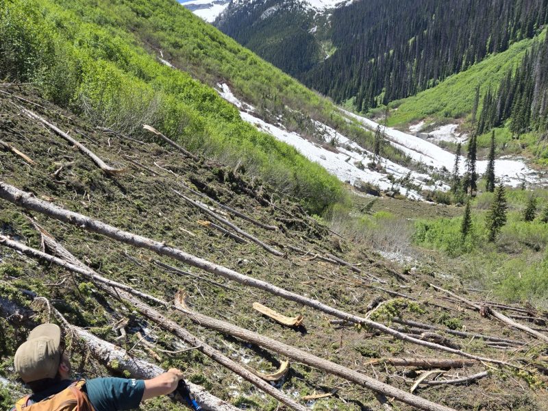
Glacier National Park trails remain closed following heavy avalanche season
Balu Pass trail, along with two others are closed indefinitely as Parks Canada staff evaluate how much of the popular trails will need to be rebuilt.