
Report studies long-term Illecillewaet River flooding potential in Revelstoke
A study commissioned by the City of Revelstoke shows that the dikes along the Illecillewaet River will withstand 200-year flooding events and the effects of climate change, but the Box Canyon log jam poses some threats.
A flood inundation study commissioned by the City of Revelstoke to determine impacts of large floods around the Illecillewaet River shows the Illecillewaet north and south dikes are in good condition and would not overtop in flood events, including with the effects of climate-change factored in.
In 2021, the City of Revelstoke commissioned a report to study the effects of climate change and evaluate the existing dike system along the Illecilllewaet River. The new Revelstoke Flood Inundation Study, prepared by WSP Canada Inc for the City of Revelstoke revealing what city staff deems “good news.”
WSP Canada Inc modelled different flood scenarios with and without the impacts of climate change to determine the adequacy of the dikes built along the Illecillewaet. The management and consultancy service company’s study models extreme flood events to figure out the expected flow.
The flood study factors in the effect of the Arrow Lakes Reservoir water levels and the primary contributor to the Illecillewaet’s high water levels, snow melt. WSP’s report found that the reservoirs levels influence the river’s flood levels up to 860 metres upstream of the Fourth Street Bridge. With this information, the study models realistic scenarios that determine flow levels expected in a 200-year flood, with and without climate change impacts. A 200-year flood has a probability of 0.5% occurrence on any given year and is the regulating size flood in B.C., used to determine the size of all dikes and span of flood maps in the province.
Report explores 1983 flood event
Although the Illecillewaet’s flow is determined primarily by snow melt, the highest flow recorded was in July 1983 due to a massive rain event. The river swelled that year, impacting the railway and other infrastructure, closing the Trans-Canada Highway for weeks. See photos from the flood here. The historical event was the basis for the city’s current flood maps which are contingent on levels recorded during 1983. The findings from this study will help to update those maps. 

The 1983 flood map shows the areas affected during the precipitation and debris flooding event. Photo: WSP Canada Inc/Flooding inundation study for City of Revelstoke
Two parties maintain the existing dikes built above and below the Fourth Street Bridge near the confluence of the Illecillewaet and Columbia River. The dikes below the Fourth Street Bridge are maintained by BC Hydro, while the ones above are the responsibility of the city. Flood-impacted areas around the river include public lands along the gymkhana access road and undeveloped lands within the southside Revelstoke area. However, the study revealed a breach of a dike could cause flooding in industrial and residential areas on the north side of the river, which would include locations such as the Downie Timber mill facilty and the Southside residential neighbourhood.

This flood map shows the freeboard the dike provides in the event of a 200-year flood with the projected effects of climate change. Photo: WSP Canada Inc/Flood inundation study for the City of Revelstoke
The study found the dikes do not overtop at any location along the river for the modelled scenarios, even with the effects of climate change. WSP determined there is an acceptable freeboard — the distance between the crest of the dike and the water level — for all dike locations, and overtopping is unlikely up to the 200-year scenario. The freeboard minimum at the Illecillewaet Dike is about 1.1 metres for the 200-year flood and 2.6 metres for the two-year flood scenarios, and one metre for the 200-year flood and 2.5 metres for the two-year flood scenarios at the Illecillewaet South Dike. However, a hazard lurks upstream in Box Canyon.
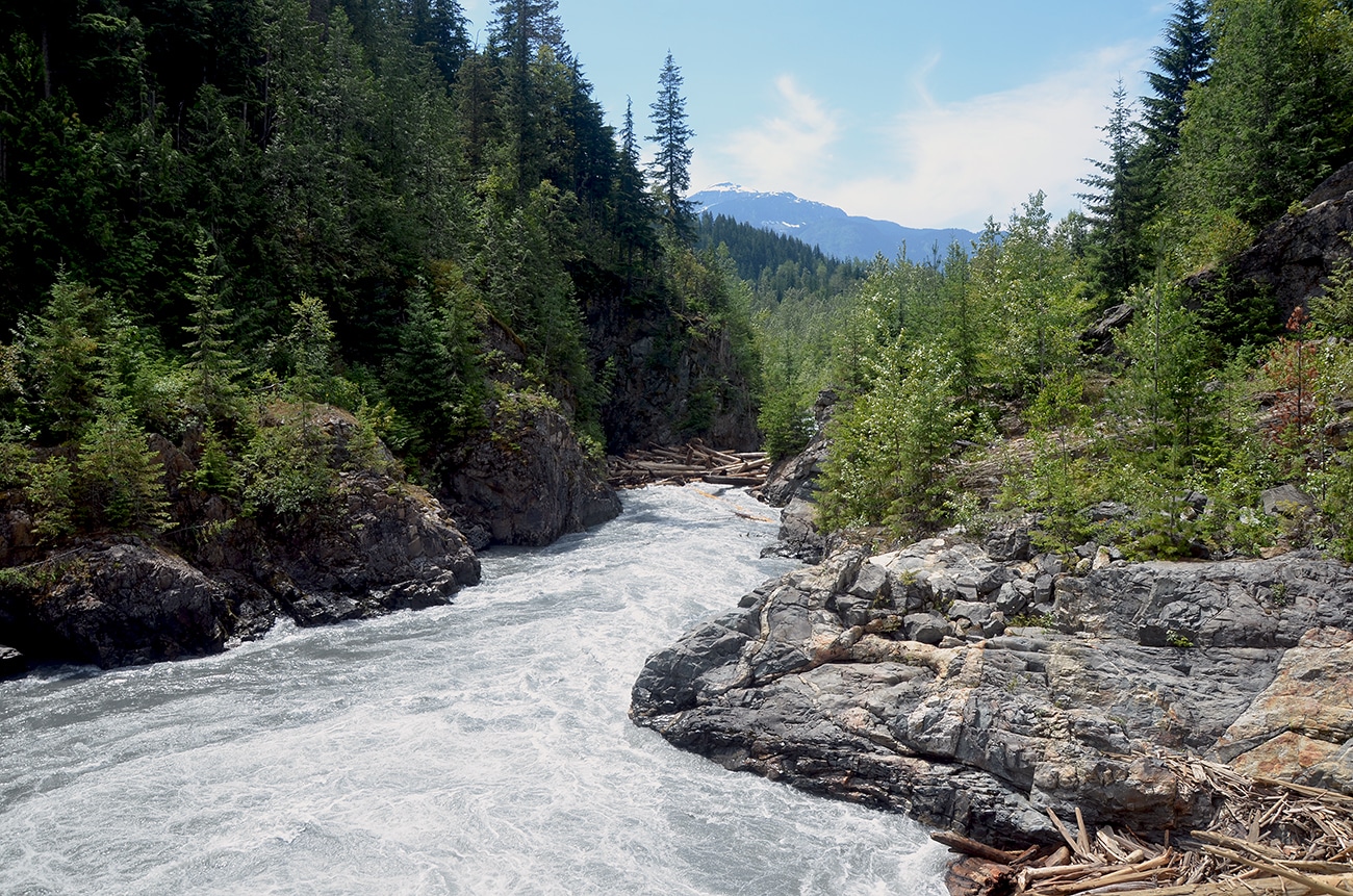
Box Canyon log jam a specific concern
The Illecillewaet’s Box Canyon is prone to log jams — big ones.
According to the flood inundation study, problems arise if the log jam releases due to a surge of water — as it has done in the past — and large piles of debris careen down the river, raising water levels significantly. If debris is released during a significant flood event, it could reduce the freeboard and jeopardize some dike sections.
A City of Revelstoke council report prepared by Director of Infrastructure and Planning, Steve Black, presented at the June 28, 2022 council meeting regarding the Flood Inundation Study, says, “[Revelstoke Fire Rescue Services] is currently working with Provincial agencies to address the log jam, to reduce the chances of the log jam impacting the [Fourth Street Bridge] in a 200-year flood event.”
During the council meeting, Mayor Gary Sulz said the city is in discussions with Emergency Management BC on how to properly deal with the log jam and who will pay for maintaining it.

The Box Canyon log jam on June 22, 2022. Photo: Jason Day
In addition, the Illecillewaet deposits a lot of sediment at the confluence due to the steep gradient of the river and creates numerous gravel bars below Box Canyon. Dredging this sediment is essential to reduce flood risks and would be detrimental to infrastructure if left unchecked and a debris and flooding event were to occur. BC Hydro is responsible for dredging the channel to prevent flooding. The study states the extent of past dredging operations is unclear and that between 1987 and 2013, dredging was done six times.
The study’s finds regular maintenance of the dike structures and sediment maintenance is essential. The WSP evaluation of the existing flood structures shows that Revelstoke’s dikes are in good condition aside from unchecked vegetation growth. However, WSP says erosion is a concern, and without upkeep, a dike could be breached and cause residential property damage.
In his report, engineer director Black said the department is creating a new team focused on the issue. “Staff will create a new sub-department titled Dike Maintenance, be included under Ditching and Drainage to better track operations and maintenance activities in the Public Works budget and $20,000 will be reallocated from the current Drainage Ditch Maintenance sub-department.”
What did you think of this story?
Your feedback after we publish a story helps ensure we're always improving our reporting to better serve you
Related Articles
Wastewater treatment plant upgrades set to future-proof facility for 2 decades
Plans to include Big Eddy residents and businesses into the updated facility still in the early stages, city director of engineering says.
Revelstoke granted $200,000 to rework development guidelines
Clarifying building requirements is key in speeding up development approvals, director of development services says.

More childcare spaces needed as families face estimated $35,000 income impact annually
Revelstoke Child Care Society still has over 160 families waitlisted as plans to expand into Okanagan College building take shape.