
Flooding closes Trans-Canada Highway west of Revelstoke near Clanwilliam
Flooding has closed the Trans-Canada Highway west of Revelstoke at around 7 a.m. on Thursday, July 2. There is no estimated reopening time.
Note: Updates follow at the bottom of this story.
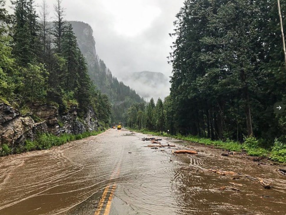
Flooding has closed the Trans-Canada Highway west of Revelstoke between Clanwilliam and the Boulder Mountain Avalanche gate on the morning of Thursday, July 2.

An image of road crews working on the flooded area of the Trans-Canada Highway near Clanwilliam. Image: Ministry of Transportation Rocky Mountain District
It rained for most of the day on Canada Day, July 1, and rain continues in the area on July 2.
Video: This video is of flooding on the Trans-Canada Highway near Clanwilliam on July 2, 2020
Nature has been keeping us busy in the Southern Interior this week.
Watch this video of the flooding happening now on #BCHwy1 10 – 15 km west of #Revelstoke.
Assessment in progress as our crews work to reopen the road. Check @DriveBC https://t.co/PatRB5HGHh#BCFlood #BCHwys pic.twitter.com/7PWdRpHkdZ
— Rocky Mountain District (@TranBCRockyMtn) July 2, 2020
Motorists began reporting trouble at the location around 7 a.m., including highway crews turning vehicles around, and Drive BC issued a warning soon after. Initial reports described the scene as a washout.
UPDATE – #BCHwy1 – Flooding between Clanwilliam OH Bridge and Boulder Mtn Avalanche gate, west of #Revelstoke. Crews are on scene. Please slow down and watch for traffic control and equipment working. More info here: https://t.co/0ocEUhrXmW pic.twitter.com/RrGYYQCJXF
— DriveBC (@DriveBC) July 2, 2020
Just before 8 a.m., DriveBC announced the highway is closed and does not currently have an estimate of reopening time.
UPDATE – CLOSED – #BCHwy1 – Flooding between Clanwilliam OH Bridge and Boulder Mtn Avalanche gate, west of #Revelstoke has the highway closed in both direction. Assessment in progress. No estimated time of opening. Next update 12 PM. More info here: https://t.co/WhL6eF1h43 pic.twitter.com/BVmF9Tew8U
— DriveBC (@DriveBC) July 2, 2020
High water year
The region had higher than average snowpack this past winter, and the past several weeks have been rainy and wet. The levels of the lakes and rivers in the vicinity of the closure, which are visible from the highway, have been very high this year.

A July 2 highway camera image at the Clanwilliam Highway overpass. Image: DriveBC
In addition, debris torrents and other issues happen periodically in the area during spring and wet summers, leading to closures. The highway is at the bottom of a steep valley in that area, and sudden warming or rainfall events can lead to sudden events that cause highway closures.
An image posted by Emcon Selkirk Division, a road maintenance contractor, shows water and mud flooding across the highway.
#BCHwy1 closed in both directions due to flooding between Woods OH Bridge and Summit Lake OH Bridge 15 km west of Revelstoke. Assessment in progress. Estimated time of reopening not available. Check @DriveBC for updates pic.twitter.com/SfcddjhRzL
— EMCON SELKIRK DIV (@EmconD) July 2, 2020
Check DriveBC for updates

An image of flooding on the Trans-Canada Highway near Clanwilliam on the morning of Thursday, July 2. Photo: Emcon Selkirk Division
Revelstokemountaineer.com may or may not update this story as events unfold. For timely road updates, check the DriveBC website.
Update: 1:15 p.m., July 2
The highway has remained closed for most of the day. Currently, DriveBC is scheduled to give an update at 4 p.m.
UPDATE – CLOSED – #BCHwy1 – Flooding 15 km west of #Revelstoke has the highway closed in both direction. Assessment in progress as crews work to reopen the road. No estimated time of opening. Next update 4 PM. #Sicamous
More info here: https://t.co/WhL6eF1h43 pic.twitter.com/s1DYRrMtHk— DriveBC (@DriveBC) July 2, 2020
Update: 4 p.m., July 2
DriveBC has no estimated opening time as of 4 p.m. and will provide another update at 5 p.m.
Update: 8:40 p.m., July 2
The highway remains closed, and vehicles have been backed up on both sides of Revelstoke. The alternate route via the Arrow Lakes ferries, is backed up for hours. DriveBC is scheduled to provide an update on the highway closure at 9 p.m. However, their current update states that the “probability of opening tonight is low” and that work is in progress.
These kind of events happen periodically at this time of year, a combination of spring runoff and wet weather events, as Revelstoke has experienced in the past few days. There can be several causes, such as a blockage of a creek, a debris torrent, a mudslide somewhere high up the mountain, a creek diversion, simply high rainfall that affects snowpack at higher elevations — or any combination of the above.
There is no way to deal with the root cause after the fact, leaving crews to do their best to mop up as best they can at the highway. In mountainous Revelstoke region, nature regularly serves up reminders of our place in the grand scheme of things.
Both major B.C. political parties, the Liberals and the NDP, have included twinning the Trans-Canada Highway from Kamloops to the Alberta border in their platforms. For decades, local and regional governments have for advocated for improvements to the route through the region. Some progress has been made, most notably with new avalanche control technology that makes the highway more reliable in the winter. However, completion of the twinning project, which would undoubtedly need to include climate change mitigation measures and improvements, is massively expensive and requires complex engineering that accounts for winter avalanche conditions, and the total cost is a moving target. Critics point out that at the current pace, where short sections of difficult terrain can cost hundreds of millions, that completion of the twinning project is many decades off.
If you’re reading this while stuck in your vehicle on the Trans-Canada, as the locals say, you’re Revelstuck. Revelstoke is an international destination with many accommodation providers. The local tourism bureau, Tourism Revelstoke, is a good place to start if you’re looking for accommodation for the night. For the most up to date highway information, DriveBC, the B.C. government’s real-time road information system, is the most timely source for the latest highway information.
Update, 9 p.m., July 2
DriveBC has updated the situation, saying the likelihood of the highway reopening tonight is low. Their next scheduled update is after midnight, at 12:15 a.m.
What did you think of this story?
Your feedback after we publish a story helps ensure we're always improving our reporting to better serve you
Related Articles
Wastewater treatment plant upgrades set to future-proof facility for 2 decades
Plans to include Big Eddy residents and businesses into the updated facility still in the early stages, city director of engineering says.
Revelstoke granted $200,000 to rework development guidelines
Clarifying building requirements is key in speeding up development approvals, director of development services says.

More childcare spaces needed as families face estimated $35,000 income impact annually
Revelstoke Child Care Society still has over 160 families waitlisted as plans to expand into Okanagan College building take shape.